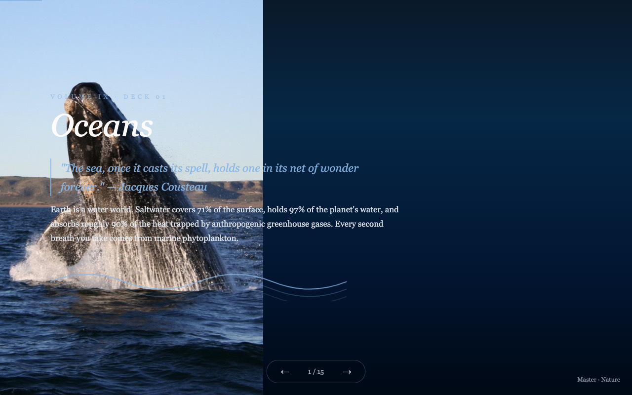
Detailed slide-by-slide text content extracted from this presentation.
Slide 01
Geology
- Reading the Rock Record
- 1 / 30
Slide 02
The Science of Deep Time
- Geology is the study of Earth's materials, structures, processes, and history across 4.54 billion years. Rocks are a physical archive of conditions that no human witnessed — deciphered through chemistry, physics, and biology working together.
- 4.54B
- Years since Earth formed from solar system debris
- 3.8B
- Years since first known life (microbial mats)
- 541M
- Years since the Cambrian explosion of complex life
- 200K
- Years since anatomically modern Homo sapiens appeared
- 2 / 30
Slide 03
Plate Tectonics
- The Theory
- Earth's lithosphere is divided into ~15 major tectonic plates floating on the semi-molten asthenosphere. Plates move 2–15 cm/year — driven by mantle convection currents and ridge-push/slab-pull forces.
- Supercontinent Cycles
- Continents assemble and disperse on ~400–500 million year cycles. Pangaea existed 335–175 Ma; Rodinia before it at ~1.1 billion years ago. The next supercontinent (Amasia) may form in 200–300 million years.
- Ocean Floor Spreading
- Mid-ocean ridges continuously create new oceanic crust as magma wells up. The Atlantic Ocean widens by 2.5 cm/year. Harry Hess proposed seafloor spreading in 1960, confirming plate tectonics.
- Subduction Zones
- Where oceanic plates dive beneath continental plates, creating deep-sea trenches, volcanic arcs, and intense earthquake activity. The Mariana Trench (11 km deep) marks where Pacific plate subducts beneath Philippine plate.
- 3 / 30
Slide 04
The Three Rock Types
- Igneous
- Formed from cooled magma or lava. Intrusive (granite, cooled slowly underground) vs extrusive (basalt, cooled rapidly at surface). Make up 90% of Earth's crust by volume.
- 🏔️
- Sedimentary
- Formed from compressed sediment layers — sand, silt, shells, organic matter. Cover 75% of Earth's land surface. The primary archive of fossils and past environments.
- Metamorphic
- Pre-existing rocks transformed by heat and pressure without melting. Marble (from limestone), slate (from shale), schist, and gneiss. Form at convergent plate margins and deep burial.
- Granite
- The most common intrusive igneous rock — large crystals from slow cooling. Forms the core of continental cratons and mountain ranges; much older than oceanic crust.
- Limestone
- Formed from marine organism shells and coral reefs. Contains 90% of Earth's biospheric carbon. Karst landscapes — sinkholes, caves, springs — form when limestone dissolves in slightly acidic water.
- Quartzite
- Metamorphosed sandstone — one of the hardest rocks. Forms prominent ridges in ancient mountain belts. Its extreme chemical inertness makes it the dominant residual mineral of intense tropical weathering.
- 4 / 30
Slide 05
Essential Minerals
- Quartz
- Most abundant mineral in Earth's continental crust. SiO₂. Forms as igneous, sedimentary, and metamorphic mineral. Sand, glass, and electronics all begin with quartz.
- Feldspar
- Most abundant mineral group overall — 60% of Earth's crust. Plagioclase and orthoclase are primary components of granite. Weathers to clay minerals that form soil.
- Olivine
- Magnesium-iron silicate; the most abundant mineral in Earth's upper mantle. Green in color. Reacts with CO₂ in enhanced weathering experiments as a potential carbon capture tool.
- Magnetite
- Iron oxide with natural magnetic properties — how compasses work. First magnetic mineral, formed in Earth's earliest rocks. Used by migratory birds for navigation.
- Pyrite
- "Fool's gold" — iron sulfide that oxidizes in air and water to produce sulfuric acid. Acid mine drainage from exposed pyrite is a major water quality problem at mining sites.
- Calcite
- Calcium carbonate — the mineral of limestone, marble, and chalk. Dissolves in acidic conditions (karst formation) and precipitates in warm, alkaline water (coral reefs, stalactites).
- 5 / 30
Slide 06
Plate Boundary Types
- Divergent Boundary
- Plates pull apart. New crust forms at mid-ocean ridges (e.g., Mid-Atlantic Ridge) or creates rift valleys on land (e.g., East African Rift, where Africa may split apart in 10M years).
- Convergent (Ocean-Continent)
- Dense oceanic plate subducts beneath lighter continental plate — forming deep trenches (Chile Trench), coastal mountain ranges (Andes), and volcanic arcs with explosive eruptions.
- Convergent (Ocean-Ocean)
- Older, denser oceanic plate subducts beneath younger. Creates island arcs (Japan, Philippines, Aleutians) with active volcanism and some of the world's deepest ocean trenches.
- Convergent (Continent-Continent)
- Neither plate subducts — collision crumples both, building massive mountain ranges. The Himalayas formed when India collided with Eurasia 50 million years ago; still rising 5mm/year.
- Transform Boundary
- Plates slide horizontally past each other. No new crust created or destroyed. The San Andreas Fault (California) is a classic example — Los Angeles moves northward toward San Francisco at 5 cm/year.
- 6 / 30
Slide 07
Earthquakes
- Seismic Waves
- P-waves (compressional, travel through solid and liquid) and S-waves (shear, solid only) move through Earth from the focus. Their different speeds and pathways reveal Earth's internal structure — our only tool for "seeing" inside the planet.
- Richter vs Moment Magnitude
- The Richter scale (logarithmic) is largely replaced by moment magnitude (Mw) — each whole number represents ~32× more energy. The 2011 Tōhoku earthquake (Mw 9.1) released energy equivalent to 600 million Hiroshima bombs.
- Ring of Fire
- The circum-Pacific belt accounts for ~90% of Earth's earthquakes and 75% of its volcanoes. Over 450 active volcanoes ring the Pacific Ocean where plates collide and subduct.
- Liquefaction
- During strong shaking, water-saturated sediments lose strength and behave like liquid — causing buildings to sink, roads to buckle, and buried tanks and pipes to float upward.
- 7 / 30
Slide 08
Volcanoes
- Types of Eruptions
- Shield volcanoes (Hawaii) produce fluid basaltic lava and gentle slopes. Stratovolcanoes (Vesuvius, Pinatubo) have high silica, explosive eruptions, and steep cones. Calderas form when magma chambers empty and collapse.
- Supervolcanoes
- Yellowstone's last supereruption (640,000 years ago) deposited ash across half of North America. A future eruption could trigger volcanic winter. Toba (74,000 years ago) may have bottlenecked the human population to tens of thousands.
- Volcanic Climate Effects
- Mount Pinatubo (1991) injected 20 million tonnes of SO₂ into the stratosphere, cooling Earth by 0.5°C for 1–2 years. The 1815 Tambora eruption caused the "Year Without a Summer" and widespread famine.
- Hotspot Chains
- Hawaii formed as the Pacific plate passed over a fixed mantle hotspot, creating an 80-million-year chain of progressively older islands to the northwest. The hotspot itself remains stationary as crust moves above it.
- 8 / 30
Slide 09
Ocean Floor Geology
- Mid-Ocean Ridges
- 65,000 km of submarine mountain ranges encircle Earth — the planet's longest topographic feature. Fresh basalt erupts continuously at spreading centers; magnetic striping in oceanic crust proved seafloor spreading.
- Abyssal Plains
- The flattest surfaces on Earth — smoothed by millennia of settling sediment. Lie 4,000–6,000m deep. Host unique fauna dependent on "marine snow" — organic particles drifting from surface waters.
- Ophiolites
- Ancient slices of oceanic crust thrust onto continents during plate collisions — giving geologists direct access to ocean floor rock. The Troodos ophiolite (Cyprus) and Oman ophiolite are world-famous examples.
- Black Smokers
- Hydrothermal vent chimneys at mid-ocean ridges exhale superheated (400°C) mineral-rich fluid. Surrounding ecosystems are powered entirely by chemosynthetic bacteria — a model for potential life on ocean worlds like Enceladus.
- 9 / 30
Slide 10
Geologic Time Scale
- 66 Ma – Now
- Cenozoic
- Age of mammals. Himalayan uplift. Grasslands expand. Antarctic glaciation. Homo sapiens arrives in the last 0.004% of this eon.
- 252–66 Ma
- Mesozoic
- Age of dinosaurs. Pangaea breaks up. Atlantic opens. Flowering plants evolve. Ends with Chicxulub impact and mass extinction.
- 541–252 Ma
- Paleozoic
- Cambrian explosion. First vertebrates, amphibians, reptiles. Pangaea assembles. Ends with the Great Dying — 96% of marine species extinct.
- 2.5B–541 Ma
- Proterozoic
- First eukaryotes. Snowball Earth events. Multicellular life evolves. Oxygen atmosphere established. Rodinia supercontinent.
- 4.54–2.5 Ga
- Archean
- Earth forms. Late Heavy Bombardment. First microbial life (stromatolites). Earliest continental crust. Reducing atmosphere without free oxygen.
- 10 / 30
Slide 11
Mountain Building (Orogeny)
- Himalayan Orogeny
- When India collided with Eurasia ~50 million years ago, the crust crumpled to form the world's highest peaks. Everest rises 8,849m — still growing 5mm/year. The uplift altered global monsoon patterns permanently.
- Appalachian-Caledonian
- Once as tall as the Himalayas, these ancient mountains formed 480–300 Ma when continents assembled into Pangaea. Now worn to gentle ridges — their roots exposed as schist and gneiss in deep erosion.
- Basin and Range
- Western North America is being stretched apart — creating alternating valleys (basins) and fault-block mountains (ranges) across Nevada and Utah. The region is a natural laboratory for extension tectonics.
- Isostasy
- Mountains have deep crustal roots — like icebergs. As mountains erode, the root floats upward (isostatic rebound), maintaining elevation. Remove a mountain quickly and the crust rebounds measurably in thousands of years.
- 11 / 30
Slide 12
Fossils & the Rock Record
- Fossilization
- Only a tiny fraction of organisms fossilize — typically hard parts (bone, shell) buried rapidly in anoxic environments. Exceptional preservation (Burgess Shale, Liaoning Formation) reveals soft tissues in rare conditions.
- Index Fossils
- Species with short existence, wide geographic range, and distinctive appearance — like trilobites and ammonites — allow geologists to date and correlate rock formations across continents without radiometric dating.
- Cambrian Explosion
- 541 million years ago, animal phyla diversified explosively over 25 million years. The Burgess Shale of British Columbia preserves soft-bodied creatures from this pivotal moment in animal evolution.
- Living Fossils
- Coelacanths (thought extinct for 65 Ma, found alive in 1938), horseshoe crabs, and Wollemi pines (135 Ma old lineage) preserve body plans little changed across hundreds of millions of years of geologic time.
- 12 / 30
Slide 13
Karst & Cave Systems
- Karst Topography
- Formed when slightly acidic groundwater dissolves limestone over millennia. Sinkholes, disappearing streams, springs, and cave systems characterize karst landscapes across Yucatan, Guilin (China), and Slovenia.
- Cave Formations
- Stalactites grow from the ceiling as calcite precipitates from dripping water; stalagmites build up from the floor. Growth rates of 0.1–10 mm/century. They record past rainfall and climate conditions in their chemistry.
- Giant Caves
- Son Doong Cave (Vietnam) is the world's largest by volume — large enough to contain a 40-story building inside. Mammoth Cave (Kentucky) has 676 km of mapped passages in a single connected system.
- Paleoclimate Archives
- Speleothems (cave formations) record oxygen isotopes that reflect past temperature and precipitation. They provide continuous paleoclimate records spanning hundreds of thousands of years — complementing ice core data.
- 13 / 30
Slide 14
Soil Formation & Geology
- Parent Material
- The underlying bedrock or transported material (glacial till, river sediment, volcanic ash) determines the mineral composition and chemical character of the soil that develops above it over centuries to millennia.
- 🌡️
- Climate
- Temperature and moisture drive weathering rate. Tropical soils weather rapidly but leach nutrients. Arctic soils are shallow and develop over millennia. Climate is the primary control on soil depth and type globally.
- Biology
- Plants, fungi, bacteria, and animals break down rock chemically (acids, chelation) and physically (roots, burrowing). Without biology, weathered rock accumulates without becoming the complex matrix we call soil.
- Topography
- Hillslopes shed material — thin, well-drained soils. Valley floors accumulate — deep, rich soils. Aspect controls solar radiation and moisture, creating north- and south-facing soil variations even within meters.
- Time
- Soils take 200–1,000 years to form 2.5 cm. Tropical laterite soils may be millions of years old. Soil formation is irreversible on human timescales — erosion losses are effectively permanent.
- 14 / 30
Slide 15
Erosion & Landscape Evolution
- Glacial Erosion
- Ice sheets and glaciers carved the landscape of northern North America and Europe during the last glaciation. U-shaped valleys, fjords, drumlins, moraines, and the Great Lakes are all glacial products.
- River Incision
- The Colorado River cut the Grand Canyon — 1.6 km deep — over 5–6 million years. River erosion rate depends on discharge, sediment load, substrate hardness, and tectonic uplift rate.
- Wind Erosion (Aeolian)
- Sand dunes cover 20% of Earth's desert area. The Sahara's dust (100 million tonnes/year) fertilizes the Amazon Basin. Wind-transported loess formed the fertile agricultural soils of the US Midwest and China.
- Mass Wasting
- Landslides, rockfalls, and debris flows move material downslope under gravity. The 1970 Nevados Huascarán landslide (Peru) buried 25,000 people. Climate change is increasing landslide frequency globally.
- 15 / 30
Slide 16
Gemstones & Precious Minerals
- Diamond
- Pure carbon crystallized under extreme pressure (150 km depth, 1200°C). Delivered to surface by kimberlite pipes. Hardest natural material (10 Mohs). Industrial diamonds power cutting and drilling globally.
- Ruby & Sapphire
- Both corundum (Al₂O₃) — color determined by trace elements (chromium for red, iron/titanium for blue). Myanmar rubies and Kashmir sapphires are among the world's most valuable gemstones per gram.
- Emerald
- Beryl colored green by chromium and vanadium. Forms in hydrothermal veins and pegmatites. Colombia produces the finest emeralds. More valuable than diamond per carat at the highest qualities.
- Gold
- Created in neutron star collisions (kilonova). Concentrated by hydrothermal fluids in quartz veins. South Africa's Witwatersrand holds the world's largest gold deposit — formed 2.9 billion years ago.
- Opal
- Amorphous silica — not technically a mineral. Play-of-color arises from diffraction of light by regular arrays of silica spheres. Australia produces 95% of the world's gem-quality opal.
- Tanzanite
- Found only in a 5 km zone near Kilimanjaro, Tanzania. Blue-violet zoisite colored by vanadium. Formed during the collision of tectonic plates 585 million years ago. A million times rarer than diamond.
- 16 / 30
Slide 17
Paleoclimatology
- Ice Core Records
- Antarctic ice cores record atmospheric CO₂ and temperature going back 800,000 years through trapped air bubbles. CO₂ has varied between 180–300 ppm naturally; we are currently at 422 ppm — unprecedented in ice core records.
- Milankovitch Cycles
- Earth's orbit varies in eccentricity (100,000 year cycle), axial tilt (41,000 years), and precession (23,000 years). These astronomical cycles modulate solar insolation, pacing glacial-interglacial cycles with remarkable regularity.
- Snowball Earth
- Between 720–635 million years ago, Earth may have been almost entirely covered in ice. The escape from Snowball Earth through volcanic CO₂ buildup may have triggered the evolution of complex multicellular life.
- PETM
- The Paleocene-Eocene Thermal Maximum (~56 Ma) saw CO₂ spike rapidly, temperatures rise 5–8°C, and ocean pH drop sharply. It is the best geological analog for our current emissions trajectory — and a warning.
- 17 / 30
Slide 18
Mass Extinctions
- End-Ordovician (443 Ma)
- ~86% of marine species lost. Caused by rapid glaciation (Gondwana ice cap) triggering sea level drop and ocean cooling. The second-largest extinction event in Earth's history.
- Late Devonian (375–359 Ma)
- ~75% of species lost over 20 million years. Likely caused by volcanic activity and the spread of land plants that altered soils, increased weathering, and caused ocean eutrophication.
- End-Permian "The Great Dying" (252 Ma)
- Earth's worst extinction — 96% of marine species and 70% of terrestrial species lost. Siberian Traps volcanism released CO₂, methane, and sulfur over 1 million years, causing warming, acidification, and anoxia simultaneously.
- End-Cretaceous (66 Ma)
- The Chicxulub asteroid impact (10 km diameter) struck Mexico at 20 km/s, releasing 100 million megatons of energy. Combined with Deccan Traps volcanism, it killed non-avian dinosaurs and ~75% of all species.
- 18 / 30
Slide 19
Earth's Magnetic Field
- Generation
- Earth's magnetic field is generated by convection in the liquid outer core — iron and nickel flowing at 50 km/year driven by temperature differences. This "geodynamo" has operated for at least 3.5 billion years.
- Polarity Reversals
- Earth's magnetic poles have reversed ~180 times in the past 83 million years. The last reversal (Brunhes-Matuyama) was 780,000 years ago. Reversals take 1,000–10,000 years and leave a record in magnetized oceanic rocks.
- Magnetosphere
- The magnetic field deflects the solar wind and cosmic rays that would otherwise strip away the atmosphere and bombard Earth's surface. Mars lost its magnetosphere 4 billion years ago and subsequently lost its atmosphere.
- Modern Weakening
- Earth's magnetic field has weakened by ~9% over the past 170 years. The South Atlantic Anomaly — a weak spot over South America — is growing. A reversal may be underway on geological timescales, though the timeline is uncertain.
- 19 / 30
Slide 20
Radiometric Dating
- Carbon-14
- Half-life 5,730 years. Uses atmospheric ¹⁴C absorbed by living organisms. Effective for materials up to ~50,000 years — archaeologic tools, wood, peat, charcoal from ancient fires.
- Potassium-Argon
- Half-life 1.25 billion years. Used for volcanic rocks from thousands to billions of years old. Dated the age of lunar basalts from Apollo samples to ~3.8 billion years.
- Uranium-Lead
- Two decay chains; half-lives of 4.5 and 0.7 billion years. Most reliable for dating ancient zircon crystals — the oldest dated material on Earth is a zircon from Australia at 4.4 billion years.
- Rubidium-Strontium
- Half-life 48.8 billion years. Used for very old rocks and meteorites. The age of the solar system (4.568 Ga) was determined using Rb-Sr dating of meteorites.
- Fission Track
- Alpha decay of uranium creates damage tracks in crystals. Annealing temperature determines when tracks begin recording — used to reconstruct cooling histories of rocks as they approach Earth's surface.
- 20 / 30
Slide 21
Ice Ages & Glaciation
- The Last Glacial Maximum
- At ~20,000 years ago, ice sheets 3–4 km thick covered North America to Ohio and Britain to England's midlands. Sea level was 120m lower. The English Channel was dry land — mammoths walked where fish swim today.
- Glacial Landforms
- Moraines (debris ridges), drumlins (streamlined hills), erratics (transported boulders far from their origin), kettle lakes (depressions from buried ice blocks), and fjords were all sculpted by glaciers and preserve a frozen record of their passage.
- Glacial Rebound
- Scandinavia is rising 8–10 mm/year as it rebounds from the weight of the last ice sheet — 3 km of ice removed since 15,000 years ago. Sea level rises in far-field areas like North America as nearby ocean basin subsides.
- Next Ice Age
- Without human greenhouse gas emissions, the next glaciation would begin in ~50,000 years as Milankovitch cycles return favorable orbital parameters. Current CO₂ levels may delay the next ice age for 100,000+ years.
- 21 / 30
Slide 22
Geological Resources
- Critical Minerals
- Lithium, cobalt, nickel, manganese, and rare earth elements are essential for batteries and electronics. Democratic Republic of Congo holds 70% of cobalt reserves; China controls 85% of rare earth processing.
- Fossil Fuels
- Coal, oil, and natural gas are ancient solar energy stored as organic carbon over millions of years. We are burning in decades what took hundreds of millions of years to accumulate — releasing long-stored carbon into the atmosphere.
- Groundwater
- Aquifers like the Ogallala (US Great Plains) and Guaraní (South America) store ancient water recharged during wetter past climates — being depleted far faster than natural recharge rates can replenish.
- Geothermal Energy
- Iceland and New Zealand produce 25–35% of electricity from geothermal — heat stored in volcanic rocks and geothermal gradients. Enhanced geothermal systems could expand this resource globally to any location with accessible hot rock.
- 22 / 30
Slide 23
Meteorites & Impact Geology
- Meteorite Types
- Chondrites (primitive, unchanged since solar system formation), achondrites (from differentiated planetesimals), iron meteorites (from planetary cores), and stony-irons. Together they record the first 10 million years of solar system history.
- Impact Craters
- ~190 confirmed impact craters on Earth (most erased by erosion and tectonics). Vredefort (South Africa, 2.02 Ga) is the largest at 300 km diameter. Barringer Crater (Arizona) is 1.2 km across and only 50,000 years old.
- Iridium Layer
- A thin layer of iridium (rare in Earth's crust but common in asteroids) found globally at the K-Pg boundary (66 Ma) was the key evidence for the Chicxulub impact — confirming the asteroid extinction hypothesis of Alvarez et al. (1980).
- Tektites
- Glass droplets formed when impact melts were ejected into the atmosphere and cooled during flight. Australites, moldavites, and Libyan desert glass link specific impact events to glass deposits thousands of kilometers from the crater.
- 23 / 30
Slide 24
Tsunamis & Coastal Geology
- Tsunami Generation
- Undersea earthquakes displacing large areas of seafloor, submarine landslides, and volcanic collapses all generate tsunamis. The 2011 Tōhoku tsunami was generated by 50m of seafloor displacement along a 500 km rupture zone.
- Wave Dynamics
- In deep water, tsunamis travel at 800 km/h with modest wave height. As they shoal in shallow water, they slow, compress, and amplify dramatically — the 2004 Indian Ocean tsunami reached heights of 30m at Sumatra's coast.
- Megatsunami Records
- Geological evidence reveals megatsunamis from massive slope failures. The Canary Islands' Cumbre Vieja volcano could generate waves 25m high reaching the US East Coast. The 8,200-year-old Storegga Slide sent a 20m wave to Scotland.
- Early Warning Systems
- DART buoys and seismometer networks now provide 15–60 minutes of warning for distant tsunamis. The 2004 Indian Ocean disaster killed 230,000 partly because no regional warning system existed; one was operational by 2006.
- 24 / 30
Slide 25
Geological Landscapes
- 🏜️
- Desert Landscapes
- Wind-carved yardangs, sand seas (ergs), deflation basins, and desert varnish. The Namib is the world's oldest desert at 55 million years — predating the Sahara by 50 million years.
- 🏔️
- Alpine Landscapes
- Arêtes, cirques, glacial tarns, and hanging valleys are sculpted by alpine glaciers. Mont Blanc's current height (4,808m) reflects a dynamic balance between tectonic uplift and erosion.
- Coastal Landscapes
- Sea stacks, arches, wave-cut platforms, and cliffs record the sea's erosive power. The White Cliffs of Dover expose 70-million-year-old chalk seafloor now tilted above sea level by Alpine uplift.
- Badlands
- Intensely eroded, sparsely vegetated terrain in soft sedimentary rock. The Badlands of South Dakota expose Oligocene mammals and the Hell Creek Formation yields T. rex fossils from 66 million years ago.
- Fluvial Landscapes
- River meanders, oxbow lakes, alluvial fans, and deltas result from the balance between stream power and sediment load. The Mississippi Delta is losing 4,000 acres/year to subsidence and sea level rise.
- Volcanic Landscapes
- Lava tubes, calderas, cinder cones, and lava flows create some of Earth's youngest landscapes. Hawaii's Big Island grows by ~180 million tonnes of lava each year — geologically newborn terrain.
- 25 / 30
Slide 26
Earth's Internal Structure
- Crust
- 0–70 km (continental); 0–10 km (oceanic)
- Continental crust is primarily granite (felsic); oceanic crust is basalt (mafic). Less than 1% of Earth's mass but where all life, water, and human activity occurs.
- Upper Mantle
- 70–660 km
- Includes the lithosphere (rigid) and asthenosphere (semi-molten, can flow over geological time). Peridotite composition. Site of partial melting that feeds volcanoes at plate boundaries.
- Lower Mantle
- 660–2,900 km
- Denser silicate minerals under immense pressure. Mantle convection currents here drive plate motion. Temperature increases from ~1,500°C to ~3,000°C with depth.
- Outer Core
- 2,900–5,150 km
- Liquid iron-nickel (~5,000°C). Convection here generates Earth's magnetic field via the geodynamo mechanism — essential for protecting life from the solar wind.
- Inner Core
- 5,150–6,371 km
- Solid iron-nickel (despite 5,700°C temperature) because of immense pressure. Rotates slightly faster than the rest of Earth. Radius ~1,220 km — almost the size of the Moon.
- 26 / 30
Slide 27
Geology & Life
- Mineral Weathering & Soil
- Silicate weathering consumes CO₂ over millions of years — the long-term thermostat of Earth's climate. Plate tectonics recycles carbon through this weathering-volcanism balance over geological time.
- Ocean Chemistry
- Hydrothermal vents at mid-ocean ridges may have been the birthplace of life — providing chemical energy gradients, mineral catalysts, and protected microenvironments where the first metabolisms could have emerged.
- Continental Drift & Evolution
- As continents separated, populations became isolated — driving speciation. The separation of South America created unique marsupial mammals; the Indian subcontinent carried its own fauna when it collided with Asia.
- Great Rift Valley & Human Evolution
- East Africa's rift system changed climate, converting forest to savanna 2–5 million years ago. This environmental pressure may have driven ancestral hominins from trees to ground locomotion — the first steps of human evolution.
- Mountain Uplift & Climate
- The Himalayan uplift increased monsoon strength and silicate weathering rates, drawing down CO₂ and cooling Earth over the past 40 million years — possibly triggering the Cenozoic glaciation that culminated in our Ice Age cycles.
- 27 / 30
Slide 28
Mohs Hardness Scale
- Talc
- So soft it can be scratched by a fingernail. Used in baby powder, cosmetics, and as a lubricant. Forms by metamorphism of magnesium-rich rocks at low temperatures.
- Gypsum
- Fingernail scratches it. Used to make plaster of Paris and drywall. Evaporite mineral formed by evaporation of saline water — ancient shallow seas left vast gypsum deposits across the US and Europe.
- Calcite
- Scratched by copper coin. Primary mineral of limestone and marble. Dissolves in acid — the basis of karst landscape formation and the test for carbonate rocks in the field.
- Apatite
- Barely scratched by steel knife. The mineral of bones and teeth. Phosphate rock (mostly apatite) is the primary source of phosphorus fertilizer — a finite, irreplaceable agricultural resource.
- Quartz
- Scratches glass. Most common mineral in continental crust. Forms beautiful crystals in geodes and veins. Desert sand and beach sand are almost entirely quartz — the final product of continental weathering.
- Diamond
- Hardest natural material — scratches everything. Only diamond cuts diamond. Used in industrial drilling, cutting, and polishing. 99.9% of diamonds mined are industrial grade; gem quality is rare.
- 28 / 30
Slide 29
Geology in the Modern World
- Seismic Hazard Mapping
- Probabilistic seismic hazard analysis informs building codes, insurance, and urban planning. Modern building codes in Japan and California have dramatically reduced earthquake casualties per event compared to 50 years ago.
- Carbon Sequestration
- Injecting CO₂ into porous basalt or sandstone formations mineralizes it into carbonate rock within years. Iceland's CarbFix project converts captured CO₂ to stone in basalt — potentially scalable to hundreds of megatons/year.
- Geoengineering
- Enhanced rock weathering — spreading crushed basalt on agricultural fields — could remove billions of tonnes of CO₂ annually while improving soil fertility. Pilot programs are underway across Europe and North America.
- Deep Drilling
- The Kola Superdeep Borehole (12.2 km, USSR) drilled for 24 years until heat made further progress impossible. It found unexpected water, biological activity, and rocks older than predicted at depth — geology has yet to be fully read.
- 29 / 30
Slide 30
Stone, Time, and the Story of Earth
- Geology teaches patience measured in millions of years. Every mountain is temporary, every ocean floor is recycled, every continent wanders. Understanding Earth's deep history is the foundation for understanding our place — and our future — in this ancient, dynamic planet.
- 4.54B
- years of Earth history
- 15 cm
- average plate movement per year
- 190+
- confirmed impact craters
- 5 km
- deepest ocean trench
- "The geological record is a history of catastrophes interrupted by periods of comparative tranquility." — Louis Agassiz
- 30 / 30